
Gracias por apoyar a este sitio ❤️
Haz una donación
Haz una donación
Mapa topográfico Rapperath
Haga clic en el mapa para ver la altitud.
Gracias por apoyar a este sitio ❤️
Haz una donación
Haz una donación
Acerca de este mapa
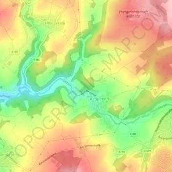
Nombre: Mapa topográfico Rapperath, altitud, relieve.
Altitud media: 454 m
Altitud mínima: 364 m
Altitud máxima: 529 m
Gracias por apoyar a este sitio ❤️
Haz una donación
Haz una donación
Otros mapas topográficos
Haga clic en un mapa para ver su topografía, su altitud y su relieve.
Weiperath
Germany > Rhineland-Palatinate > Landkreis Bernkastel-Wittlich > Morbach
The municipality lies at an elevation of between 430 and 770 m above sea level in the low mountain range of the Hunsrück on the boundary with the Birkenfeld district, roughly 25 km southeast of Wittlich and 35 km east of Trier. Its population is 11,051. The nearest town is Bernkastel-Kues.
Altitud media: 439 m