
Gracias por apoyar a este sitio ❤️
Haz una donación
Haz una donación
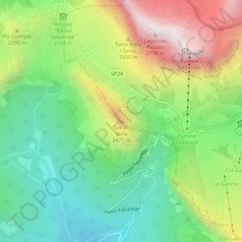
Mapa topográfico Sas de Stria
Haga clic en el mapa para ver la altitud.
Gracias por apoyar a este sitio ❤️
Haz una donación
Haz una donación
Sas de Stria
Sass de Stria is a mountain of the Veneto, Italy. It has an elevation of 2,477 meters. During the First World War, the mountain and surrounding area was the scene of fighting between Italy and Austria-Hungary.
Gracias por apoyar a este sitio ❤️
Haz una donación
Haz una donación
Acerca de este mapa
Nombre: Mapa topográfico Sas de Stria, altitud, relieve.
Lugar: Sas de Stria, Cortina d'Ampezzo, Belluno, Veneto, Italy (46.51988 11.99782 46.51998 11.99792)
Altitud media: 2.138 m
Altitud mínima: 1.751 m
Altitud máxima: 2.757 m
Gracias por apoyar a este sitio ❤️
Haz una donación
Haz una donación