
Gracias por apoyar a este sitio ❤️
Haz una donación
Haz una donación
Mapa topográfico Lembach
Haga clic en el mapa para ver la altitud.
Gracias por apoyar a este sitio ❤️
Haz una donación
Haz una donación
Lembach
The commune, which covers an extensive land area, much of it uninhabitable owing to the topography, also includes the small village of Mattstall and the hamlet of Pfaffenbronn.
Gracias por apoyar a este sitio ❤️
Haz una donación
Haz una donación
Acerca de este mapa
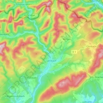
Nombre: Mapa topográfico Lembach, altitud, relieve.
Altitud media: 319 m
Altitud mínima: 169 m
Altitud máxima: 550 m
Gracias por apoyar a este sitio ❤️
Haz una donación
Haz una donación
Otros mapas topográficos
Haga clic en un mapa para ver su topografía, su altitud y su relieve.
Gracias por apoyar a este sitio ❤️
Haz una donación
Haz una donación
Gracias por apoyar a este sitio ❤️
Haz una donación
Haz una donación