
Mapa topográfico Newport County
Mapa interactivo
Haga clic en el mapa para ver la altitud.
Acerca de este mapa
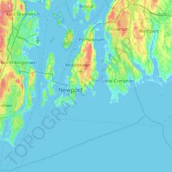
Nombre: Mapa topográfico Newport County, altitud, relieve.
Lugar: Newport County, Rhode Island, United States (41.30736 -71.50944 41.69050 -71.08857)
Altitud media: 14 m
Altitud mínima: -7 m
Altitud máxima: 130 m
The county consists of Aquidneck Island, Conanicut Island, Prudence Island, and the easternmost portion of the state on the mainland. The highest point in the county is Pocasset Hill, 320 feet (98 m) above sea level, located in Tiverton. The lowest elevation is at sea level.
Otros mapas topográficos
Haga clic en un mapa para ver su topografía, su altitud y su relieve.
Barrington
United States > Rhode Island > Bristol County
Barrington, Bristol County, Rhode Island, 02806, United States
Altitud media: 4 m
Cumberland
United States > Rhode Island > Providence County
Cumberland, Providence County, Rhode Island, 02864, United States
Altitud media: 76 m
Warwick
United States > Rhode Island > Kent County
Warwick, Kent County, Rhode Island, United States
Altitud media: 16 m
Aquidneck Island
United States > Rhode Island > Newport County > Portsmouth
Aquidneck Island, Portsmouth, Newport County, Rhode Island, United States
Altitud media: 13 m
Goat Island
United States > Rhode Island > Newport County > Newport
Goat Island, Newport, Newport County, Rhode Island, United States
Altitud media: 2 m
Westerly
United States > Rhode Island > South County
Westerly, South County, Rhode Island, 02808, United States
Altitud media: 19 m
Tiverton
United States > Rhode Island > Newport County
Tiverton, Newport County, Rhode Island, 02878, United States
Altitud media: 31 m
South Kingstown
United States > Rhode Island > South County
South Kingstown, South County, Rhode Island, United States
Altitud media: 30 m
Chopmist
United States > Rhode Island > Providence County > Scituate
Chopmist, Scituate, Providence County, Rhode Island, 02857, United States
Altitud media: 175 m
Diamond Hill
United States > Rhode Island > Providence County > Cumberland
Diamond Hill, Cumberland, Providence County, Rhode Island, 02864, United States
Altitud media: 80 m
Providence
United States > Rhode Island > Providence County
Providence, Providence County, Rhode Island, United States
Altitud media: 19 m
Charlestown
United States > Rhode Island > South County
Charlestown, South County, Rhode Island, 02813, United States
Altitud media: 22 m
Cranston
United States > Rhode Island > Providence County
Cranston, Providence County, Rhode Island, United States
Altitud media: 27 m
Jamestown
United States > Rhode Island > Newport County
Jamestown, Newport County, Rhode Island, 02835, United States
Altitud media: 8 m
Wakefield
United States > Rhode Island > South County > South Kingstown
Wakefield, South Kingstown, South County, Rhode Island, 02879, United States
Altitud media: 23 m
West Warwick
United States > Rhode Island > Kent County
West Warwick, Kent County, Rhode Island, United States
Altitud media: 59 m
East Providence
United States > Rhode Island > Providence County
East Providence, Providence County, Rhode Island, United States
Altitud media: 12 m
Middletown
United States > Rhode Island > Newport County
Middletown, Newport County, Rhode Island, 02842, United States
Altitud media: 19 m
Masonic - Shriners Family Center
United States > Rhode Island > Kent County > Warwick
Masonic - Shriners Family Center, Warwick, Kent County, Rhode Island, United States
Altitud media: 7 m
James V. Turner Reservoir
United States > Rhode Island > Providence County > East Providence > Rumford
James V. Turner Reservoir, Rumford, East Providence, Providence County, Rhode Island, United States
Altitud media: 14 m
Page Island
United States > Rhode Island > Providence County > Pascoag
Page Island, Pascoag, Providence County, Rhode Island, 02859, United States
Altitud media: 124 m
West Warwick
United States > Rhode Island > Kent County
West Warwick, Kent County, Rhode Island, 02893, United States
Altitud media: 60 m
Portsmouth
United States > Rhode Island > Newport County
Portsmouth, Newport County, Rhode Island, United States
Altitud media: 19 m
Narragansett Town Beach
United States > Rhode Island > South County > Narragansett > Narragansett Pier
Narragansett Town Beach, Narragansett Beach, Narragansett Pier, Narragansett, South County, Rhode Island, United States
Altitud media: 6 m
Pawtucket
United States > Rhode Island > Providence County
Pawtucket, Providence County, Rhode Island, United States
Altitud media: 24 m
Narragansett Bay
United States > Rhode Island > Newport County
Narragansett Bay, Newport County, Rhode Island, 02783, United States
Altitud media: 4 m
Bristol
United States > Rhode Island > Bristol County
Bristol, Bristol County, Rhode Island, 02809, United States
Altitud media: 6 m
Coventry
United States > Rhode Island > Kent County
Coventry, Kent County, Rhode Island, United States
Altitud media: 126 m
Central Falls
United States > Rhode Island > Providence County
Central Falls, Providence County, Rhode Island, United States
Altitud media: 22 m
Little Compton
United States > Rhode Island > Newport County
Little Compton, Newport County, Rhode Island, United States
Altitud media: 9 m
Hell's Half Acre
United States > Rhode Island > Kent County > West Greenwich
Hell's Half Acre, West Greenwich, Kent County, Rhode Island, 02822, United States
Altitud media: 110 m
Warren
United States > Rhode Island > Bristol County
Warren, Bristol County, Rhode Island, 02885, United States
Altitud media: 6 m
Roosevelt Lake
United States > Rhode Island > Providence County > Providence
Roosevelt Lake, Providence, Providence County, Rhode Island, United States
Altitud media: 12 m
North Providence
United States > Rhode Island > Providence County
North Providence, Providence County, Rhode Island, 02911, United States
Altitud media: 53 m
Woonsocket
United States > Rhode Island > Providence County
Woonsocket, Providence County, Rhode Island, 02895, United States
Altitud media: 74 m
Cunliff Pond Dam
United States > Rhode Island > Providence County > Providence
Cunliff Pond Dam, Providence, Providence County, Rhode Island, 02905, United States
Altitud media: 9 m
Green Hill Point
United States > Rhode Island > South County > South Kingstown > Green Hill
Green Hill Point, Green Hill, South Kingstown, South County, Rhode Island, United States
Altitud media: 2 m
Providence River
United States > Rhode Island > Providence County > Providence
Providence River, Providence, Providence County, Rhode Island, 02903, United States
Altitud media: 9 m
Block Island
United States > Rhode Island > South County > New Shoreham
Block Island, New Shoreham, South County, Rhode Island, 02807, United States
Altitud media: 5 m
Prudence Island
United States > Rhode Island > Newport County > Portsmouth
Prudence Island, Portsmouth, Newport County, Rhode Island, United States
Altitud media: 6 m
Newport
United States > Rhode Island > Newport County
Newport, Newport County, Rhode Island, 02840, United States
Altitud media: 8 m
Narragansett
United States > Rhode Island > South County
Narragansett, South County, Rhode Island, 02882, United States
Altitud media: 12 m
Crompton
United States > Rhode Island > Kent County > West Warwick
Crompton, West Warwick, Kent County, Rhode Island, 02893, United States
Altitud media: 63 m
North Kingstown
United States > Rhode Island > South County
North Kingstown, South County, Rhode Island, United States
Altitud media: 35 m
Misquamicut
United States > Rhode Island > Washington County > Westerly
Misquamicut, Westerly, Washington County, Rhode Island, 02891, United States
Altitud media: 6 m
North Smithfield
United States > Rhode Island > Providence County > North Smithfield
North Smithfield, Providence County, Rhode Island, United States
Altitud media: 96 m
Providence County
Providence County, Rhode Island, United States
Altitud media: 108 m
Burrillville
United States > Rhode Island > Providence County
Burrillville, Providence County, Rhode Island, United States
Altitud media: 155 m
South County
South County, Rhode Island, United States
Altitud media: 30 m
Newton Swamp Management Area
United States > Rhode Island > South County > Westerly
Newton Swamp Management Area, McGowan Corners, Westerly, South County, Rhode Island, 02808, United States
Altitud media: 22 m