
Mapa topográfico Florenville
Mapa interactivo
Haga clic en el mapa para ver la altitud.
Acerca de este mapa
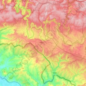
Nombre: Mapa topográfico Florenville, altitud, relieve.
Lugar: Florenville, Virton, Luxemburg, Wallonië, België (49.61078 5.14709 49.78127 5.42495)
Altitud media: 316 m
Altitud mínima: 160 m
Altitud máxima: 452 m
Otros mapas topográficos
Haga clic en un mapa para ver su topografía, su altitud y su relieve.
Semois
België > Luxemburg > Virton > Les Bulles
Semois, Les Bulles, Chiny, Virton, Luxemburg, Wallonië, 6811, België
Altitud media: 332 m
Sainte-Cécile
België > Luxemburg > Virton > Sainte-Cécile
Sainte-Cécile, Florenville, Virton, Luxemburg, Wallonië, België
Altitud media: 348 m
Saint-Mard
België > Luxemburg > Virton > Virton
Saint-Mard, Virton, Luxemburg, Wallonië, 6762, België
Altitud media: 272 m
Gérouville
België > Luxemburg > Virton > Gérouville
Gérouville, Meix-devant-Virton, Virton, Luxemburg, Wallonië, 6769, België
Altitud media: 291 m