
Mapa topográfico Unokoti
Mapa interactivo
Haga clic en el mapa para ver la altitud.
Acerca de este mapa
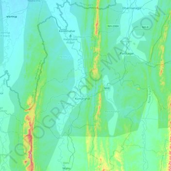
Nombre: Mapa topográfico Unokoti, altitud, relieve.
Lugar: Unokoti, Tripura, India (23.99051 91.90787 24.39156 92.20439)
Altitud media: 70 m
Altitud mínima: 17 m
Altitud máxima: 430 m
The topographic features seem to have influenced the climatic condition of the Unakoti district, where the plains are hotter and humid in comparison to the hills, which have a salubrious climate. The four main seasons here are
Otros mapas topográficos
Haga clic en un mapa para ver su topografía, su altitud y su relieve.
Haora River
Haora River, Agartala, West Tripura, Tripura, 799001, India
Altitud media: 18 m
Kailashahar
India > Tripura > Gournagar > Kailashahar
Kailashahar, Gournagar, Unokoti, Tripura, 799277, India
Altitud media: 33 m
South Tripura
India > Tripura > South Tripura
South Tripura, Gomati, Tripura, India
Altitud media: 75 m