
Gracias por apoyar a este sitio ❤️
Haz una donación
Haz una donación
Mapa topográfico Hunters Park
Haga clic en el mapa para ver la altitud.
Gracias por apoyar a este sitio ❤️
Haz una donación
Haz una donación
Acerca de este mapa
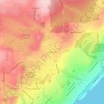
Nombre: Mapa topográfico Hunters Park, altitud, relieve.
Altitud media: 333 m
Altitud mínima: 179 m
Altitud máxima: 433 m
Gracias por apoyar a este sitio ❤️
Haz una donación
Haz una donación
Otros mapas topográficos
Haga clic en un mapa para ver su topografía, su altitud y su relieve.
West Duluth
United States > Minnesota > Saint Louis County > Duluth
West Duluth covers an area of 5,726 acres (23 km2), or 13% of the city area, making it the third-largest district in the city. Note that, as with many other Duluth neighborhood districts, the area actually developed to a major extent is considerably smaller than the district figure. This is largely due to the…
Altitud media: 252 m
Gracias por apoyar a este sitio ❤️
Haz una donación
Haz una donación