
Gracias por apoyar a este sitio ❤️
Haz una donación
Haz una donación
Mapa topográfico Warstein
Haga clic en el mapa para ver la altitud.
Gracias por apoyar a este sitio ❤️
Haz una donación
Haz una donación
Warstein
Warstein is located north of the Arnsberger Wald (forest), at a brook called Wäster. The area south of the city is mostly forested; the lightly forested Haarstrang mountain is to the north. The river Möhne flows between these two areas. The highest elevation is 581 m (1,906 ft) in the south of the city near a hill called Stimm Stamm; the lowest elevation is 216 m (709 ft) in the village Waldhausen in the north.
Gracias por apoyar a este sitio ❤️
Haz una donación
Haz una donación
Acerca de este mapa
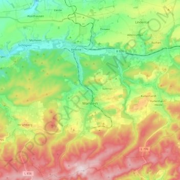
Nombre: Mapa topográfico Warstein, altitud, relieve.
Lugar: Warstein, Kreis Soest, North Rhine-Westphalia, 59581, Germany (51.38855 8.20178 51.52277 8.40984)
Altitud media: 373 m
Altitud mínima: 223 m
Altitud máxima: 582 m
Gracias por apoyar a este sitio ❤️
Haz una donación
Haz una donación
Otros mapas topográficos
Haga clic en un mapa para ver su topografía, su altitud y su relieve.