
Mapa topográfico Croydon
Haga clic en el mapa para ver la altitud.
Croydon
Several apartment developments, for instance Altitude 25 (completed 2010), have been built in recent years, and several more are being built or planned. The construction of Saffron Square, which includes a 43-storey tower, began on Wellesley Road in 2011 and was completed in 2016. Other developments with towers over 50 floors high have been given planning approval. These include the 54-storey "Menta Tower" in Cherry Orchard Road near East Croydon station, and a 55-storey tower at One Lansdowne Road, on which construction was set to begin in early 2013. The latter is set to be Britain's tallest block of flats, including office space, a four-star hotel and a health club.
Acerca de este mapa
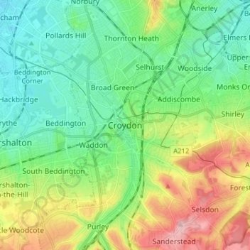
Nombre: Mapa topográfico Croydon, altitud, relieve.
Lugar: Croydon, Greater London, England, CR0 1SZ, United Kingdom (51.33130 -0.14196 51.41130 -0.06196)
Altitud media: 70 m
Altitud mínima: 20 m
Altitud máxima: 175 m
Otros mapas topográficos
Haga clic en un mapa para ver su topografía, su altitud y su relieve.
Norwood Grove
United Kingdom > England > Greater London
After Anderson died, ownership passed to the Nettlefold family and subsequently to Frederick Nettlefold the brother of Joseph Nettlefold and a member of the family that founded the Nettlefolds Ltd. engineering firm which later became GKN. Nettlefold is commemorated, as a result of his charitable works, by a…
Altitud media: 58 m
Pymmes Brook
United Kingdom > England > Greater London
Prior to the Anglian glaciation, a "proto-Mole-Wey" river was flowing northwards from the Weald and North Downs, through the "Finchley depression" and Palmers Green, to join the proto-Thames somewhere around Hoddesdon, at what is today an altitude of around 60 metres. It was this river which, during the course…
Altitud media: 41 m