
Mapa topográfico Wild River State Park
Mapa interactivo
Haga clic en el mapa para ver la altitud.
Acerca de este mapa
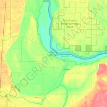
Nombre: Mapa topográfico Wild River State Park, altitud, relieve.
Altitud media: 262 m
Altitud mínima: 227 m
Altitud máxima: 310 m
Otros mapas topográficos
Haga clic en un mapa para ver su topografía, su altitud y su relieve.
Osceola
United States > Wisconsin > Polk County
Osceola, Polk County, Wisconsin, United States
Altitud media: 261 m
Luck
United States > Wisconsin > Polk County
Luck, Polk County, Wisconsin, United States
Altitud media: 379 m
Balsam Lake
United States > Wisconsin > Polk County
Balsam Lake, Polk County, Wisconsin, United States
Altitud media: 354 m
Town of Bone Lake
United States > Wisconsin > Polk County
Town of Bone Lake, Polk County, Wisconsin, United States
Altitud media: 378 m
Clayton
United States > Wisconsin > Polk County
Clayton, Polk County, Wisconsin, United States
Altitud media: 370 m
Frederic
United States > Wisconsin > Polk County
Frederic, Polk County, Wisconsin, United States
Altitud media: 373 m
Little Falls
United States > Wisconsin > Polk County
Little Falls, Town of Alden, Polk County, Wisconsin, United States
Altitud media: 326 m
Peaslee Lake
United States > Wisconsin > Polk County
Peaslee Lake, Town of Osceola, Polk County, Wisconsin, United States
Altitud media: 241 m
Clear Lake Village Park
United States > Wisconsin > Polk County > Clear Lake
Clear Lake Village Park, Clear Lake, Town of Clear Lake, Polk County, Wisconsin, United States
Altitud media: 368 m
Cushing
United States > Wisconsin > Polk County
Cushing, Town of Laketown, Polk County, Wisconsin, 54006, United States
Altitud media: 298 m
Amery
United States > Wisconsin > Polk County
Amery, Polk County, Wisconsin, United States
Altitud media: 330 m
Clear Lake
United States > Wisconsin > Polk County
Clear Lake, Polk County, Wisconsin, United States
Altitud media: 362 m