
Haz una donación
Mapa topográfico Pleinfeld
Haga clic en el mapa para ver la altitud.
Haz una donación
Pleinfeld
Pleinfeld is situated on the rivers Swabian Rezat and Arbach, 8 kilometres (5.0 mi) north of Weißenburg in Bayern, and 45 kilometres (28 mi) south of Nuremberg. Other rivers in the municipality area are Brombach river and Banzerbach river, both tributary of the Swabian Rezat. The town's altitude is around 382 metres (1,253 feet) above sea level. The highest point of the municipality is located near Dorsbrunn, 505 m (1,657 ft) asl. Pleinfeld is the biggest town at the Großer Brombachsee, a lake in the Franconian Lake District. Simultaneously, Pleinfeld is located on the most northern part of the Altmühl Valley Nature Park.
Haz una donación
Acerca de este mapa
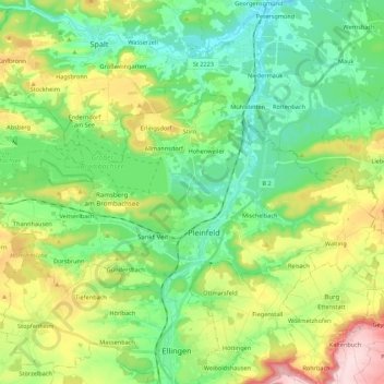
Nombre: Mapa topográfico Pleinfeld, altitud, relieve.
Lugar: Pleinfeld, Weißenburg-Gunzenhausen, Bavaria, 91785, Germany (49.08332 10.87587 49.15750 11.09330)
Altitud media: 431 m
Altitud mínima: 342 m
Altitud máxima: 618 m
Haz una donación
Otros mapas topográficos
Haga clic en un mapa para ver su topografía, su altitud y su relieve.