
Gracias por apoyar a este sitio ❤️
Haz una donación
Haz una donación
Mapa topográfico Kolbermoor
Haga clic en el mapa para ver la altitud.
Gracias por apoyar a este sitio ❤️
Haz una donación
Haz una donación
Acerca de este mapa
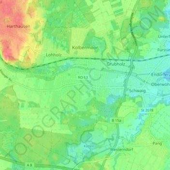
Nombre: Mapa topográfico Kolbermoor, altitud, relieve.
Lugar: Kolbermoor, Landkreis Rosenheim, Bavaria, 83059, Germany (47.81625 12.00213 47.87050 12.08417)
Altitud media: 467 m
Altitud mínima: 446 m
Altitud máxima: 504 m
Gracias por apoyar a este sitio ❤️
Haz una donación
Haz una donación
Otros mapas topográficos
Haga clic en un mapa para ver su topografía, su altitud y su relieve.
Kampenwand-Hauptgipfel
Germany > Bavaria > Landkreis Rosenheim > Aschau im Chiemgau
Altitud media: 1.272 m
Gracias por apoyar a este sitio ❤️
Haz una donación
Haz una donación
Gracias por apoyar a este sitio ❤️
Haz una donación
Haz una donación
Wasserburg am Inn
Germany > Bavaria > Landkreis Rosenheim > Wasserburg am Inn > Wasserburg am Inn
Altitud media: 477 m
Geigelstein
Germany > Bavaria > Landkreis Rosenheim > Aschau im Chiemgau
Geigelstein is a mountain in Bavaria, Germanywith an elevation of 1,808 meters. It is a mountain within the Chiemgau Alps.
Altitud media: 1.443 m