
Haz una donación
Mapa topográfico Boulder City
Haga clic en el mapa para ver la altitud.
Haz una donación
Acerca de este mapa
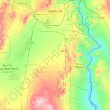
Nombre: Mapa topográfico Boulder City, altitud, relieve.
Lugar: Boulder City, Clark County, Nevada, 89005, United States (35.67696 -115.10173 36.01137 -114.76992)
Altitud media: 659 m
Altitud mínima: 192 m
Altitud máxima: 1.488 m
Haz una donación
Otros mapas topográficos
Haga clic en un mapa para ver su topografía, su altitud y su relieve.
Blue Diamond
United States > Nevada > Clark County
Blue Diamond is the site of Cottonwood Spring (formerly known as Ojo de Cayetana, or Pearl Spring), a watering place and campsite on the Old Spanish Trail and the later Mormon Road between Mountain Springs and Las Vegas Springs. The springs are located on a mountainside south of the town at 36°02′44″N…
Altitud media: 1.106 m
Haz una donación
Highland Range Crucial Bighorn Habitat Area
United States > Nevada > Clark County
Altitud media: 917 m
Haz una donación
Mount Charleston
United States > Nevada > Clark County
The town of Mount Charleston is named for nearby Mount Charleston whose Charleston Peak at 11,916 feet (3,632 m) is the highest point in Clark County. The town of Mount Charleston is in a valley of the Spring Mountains to the northwest of Las Vegas, noted for its hiking trails. It is also known for its Retreat…
Altitud media: 2.594 m
Spring Mountain Ranch State Park
United States > Nevada > Clark County
"Because of the higher elevation, the ranch offers a diverse opportunity for plant study. Four plant communities are represented: Desert Scrub, Black brush, Pinon-Juniper, and Riparian. Plants typical of the desert as well as woodland can be seen, and with adequate rainfall the spring brings a burst of…
Altitud media: 1.188 m
Haz una donación
Mount Charleston
United States > Nevada > Clark County
The town of Mount Charleston is named for nearby Mount Charleston whose Charleston Peak at 11,916 feet (3,632 m) is the highest point in Clark County. The town of Mount Charleston is in a valley of the Spring Mountains to the northwest of Las Vegas, noted for its hiking trails. It is also known for its Retreat…
Altitud media: 2.594 m
Haz una donación
Haz una donación
Craig Ranch Regional Park
United States > Nevada > Clark County > North Las Vegas
Altitud media: 626 m
Haz una donación
Haz una donación