
Gracias por apoyar a este sitio ❤️
Haz una donación
Haz una donación
Mapa topográfico Fischen
Haga clic en el mapa para ver la altitud.
Gracias por apoyar a este sitio ❤️
Haz una donación
Haz una donación
Acerca de este mapa
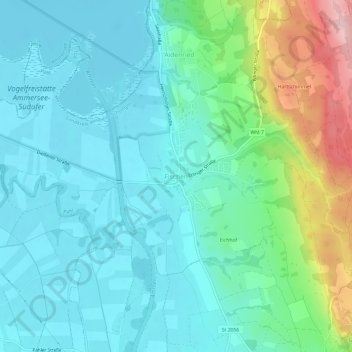
Nombre: Mapa topográfico Fischen, altitud, relieve.
Altitud media: 577 m
Altitud mínima: 530 m
Altitud máxima: 737 m
Gracias por apoyar a este sitio ❤️
Haz una donación
Haz una donación
Otros mapas topográficos
Haga clic en un mapa para ver su topografía, su altitud y su relieve.
Hohenpeißenberg
Germany > Bavaria > Landkreis Weilheim-Schongau
The climate is oceanic (Köppen: Cfb), affected by altitude and proximity to the Alps (especially in precipitation). Registering data continuously since 1781, the Hohenpeißenberg Observatory is the oldest in the world located on a mountain. The station located in the alpine foothills integrates the German…
Altitud media: 732 m
Gracias por apoyar a este sitio ❤️
Haz una donación
Haz una donación
Gracias por apoyar a este sitio ❤️
Haz una donación
Haz una donación