
Gracias por apoyar a este sitio ❤️
Haz una donación
Haz una donación
Mapa topográfico Tuttendorf
Haga clic en el mapa para ver la altitud.
Gracias por apoyar a este sitio ❤️
Haz una donación
Haz una donación
Acerca de este mapa
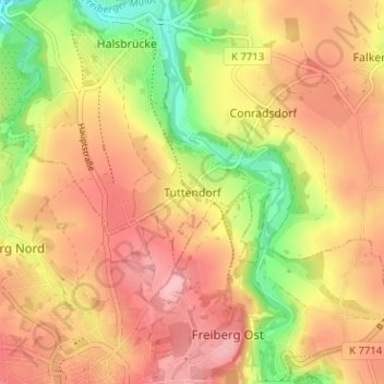
Nombre: Mapa topográfico Tuttendorf, altitud, relieve.
Lugar: Tuttendorf, Halsbrücke, Mittelsachsen, Saxony, 09599, Germany (50.91850 13.34117 50.95850 13.38117)
Altitud media: 376 m
Altitud mínima: 297 m
Altitud máxima: 431 m
Gracias por apoyar a este sitio ❤️
Haz una donación
Haz una donación
Otros mapas topográficos
Haga clic en un mapa para ver su topografía, su altitud y su relieve.
Gracias por apoyar a este sitio ❤️
Haz una donación
Haz una donación
Freiberg
Germany > Saxony > Mittelsachsen
The town lies on the northern declivity of the Ore Mountains, with the majority of the borough west of the Eastern or Freiberger Mulde river. Parts of the town are nestled in the valleys of Münzbach and Goldbach streams. Its centre has an altitude of about 412 m above sea level (NHN) (at the railway station).…
Altitud media: 405 m
Gracias por apoyar a este sitio ❤️
Haz una donación
Haz una donación