
Gracias por apoyar a este sitio ❤️
Haz una donación
Haz una donación
Mapa topográfico Elba
Haga clic en el mapa para ver la altitud.
Gracias por apoyar a este sitio ❤️
Haz una donación
Haz una donación
Acerca de este mapa
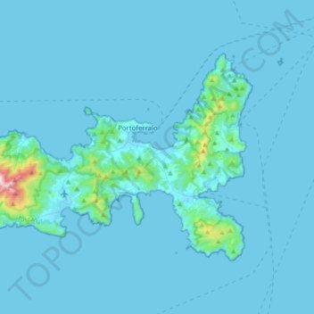
Nombre: Mapa topográfico Elba, altitud, relieve.
Lugar: Elba, Livorno, Tuscany, Italy (42.70750 10.10250 42.87295 10.44414)
Altitud media: 34 m
Altitud mínima: -1 m
Altitud máxima: 925 m
Gracias por apoyar a este sitio ❤️
Haz una donación
Haz una donación
Otros mapas topográficos
Haga clic en un mapa para ver su topografía, su altitud y su relieve.
Populonia
Italy > Tuscany > Livorno > Piombino
In geology, the "Tuscan metallogenic province" derived from volcanic intrusions into southern Etruria due to extension of the crust there (which also created a karst topography in western Italy) from the late Miocene to the Pleistocene. This process emplaced iron oxide deposits on Elba, pyrite in southern…
Altitud media: 34 m
Gracias por apoyar a este sitio ❤️
Haz una donación
Haz una donación
Gracias por apoyar a este sitio ❤️
Haz una donación
Haz una donación