
Haz una donación
Mapa topográfico Kyritz
Haga clic en el mapa para ver la altitud.
Haz una donación
Acerca de este mapa
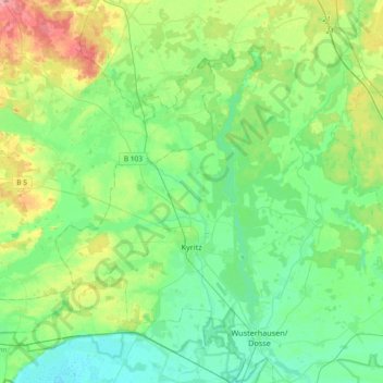
Nombre: Mapa topográfico Kyritz, altitud, relieve.
Lugar: Kyritz, Ostprignitz-Ruppin, Brandenburg, 16866, Germany (52.89267 12.18952 53.05692 12.55734)
Altitud media: 51 m
Altitud mínima: 26 m
Altitud máxima: 117 m
Haz una donación
Otros mapas topográficos
Haga clic en un mapa para ver su topografía, su altitud y su relieve.
North European Plain
Germany > Brandenburg > Ostprignitz-Ruppin > Lindow (Mark)
Elevations vary between 0 and 200 m (0 to about 650 ft). While mostly used as farmland, the region also contains bogs, heath and lakes. The Wadden Sea, a large tidal area, is located on the North Sea coast.
Altitud media: 54 m
North European Plain
Germany > Brandenburg > Ostprignitz-Ruppin > Lindow (Mark) > Banzendorf
Elevations vary between 0 and 200 m (0 to about 650 ft). While mostly used as farmland, the region also contains bogs, heath and lakes. The Wadden Sea, a large tidal area, is located on the North Sea coast.
Altitud media: 54 m