
Haz una donación
Mapa topográfico Roosevelt
Haga clic en el mapa para ver la altitud.
Haz una donación
Roosevelt
Roosevelt is situated on U.S. Route 40 in the northeast corner of the state, south of the Uinta Mountains, at an elevation of 5,250 feet (1,600 m). The town was incorporated at a mass meeting of 44 citizens on 21 February 1913. From 1906 to 1914 Roosevelt was in Wasatch County, but in 1914 Duchesne County was formed from part of Wasatch County, and, as the largest town in the county, Roosevelt anticipated becoming the county seat. However, when the total county-wide vote came in, the seat went to Duchesne.
Haz una donación
Acerca de este mapa
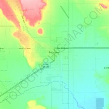
Nombre: Mapa topográfico Roosevelt, altitud, relieve.
Lugar: Roosevelt, Duchesne County, Utah, 84066, United States (40.26228 -110.06801 40.33372 -109.97657)
Altitud media: 1.553 m
Altitud mínima: 1.513 m
Altitud máxima: 1.645 m
Haz una donación
Otros mapas topográficos
Haga clic en un mapa para ver su topografía, su altitud y su relieve.
Kings Peak
United States > Utah > Duchesne County
Kings Peak is the highest peak in the U.S. state of Utah, with an elevation of 13,528 feet (4,123 m) NAVD 88.
Altitud media: 3.743 m