
Haz una donación
Mapa topográfico Bad Essen
Haga clic en el mapa para ver la altitud.
Haz una donación
Bad Essen
The town of Bad Essen is on the North German Plains, because of the transition of the low mountain range to the plains. The Wiehengebirge Range covers approximately the southern third of the town and reaches an elevation of 211m above sea level. The highest point of the Wiehengebirge Range is on the black Brink in Lintorf. The northern part of the town is flat, with an average elevation of 50m above sea level. The Hunte flows through the eastern part of Bad Essen northwards and crosses the Midland Canal in Wittlage.
Haz una donación
Acerca de este mapa
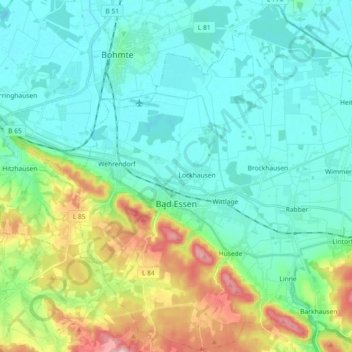
Nombre: Mapa topográfico Bad Essen, altitud, relieve.
Lugar: Bad Essen, Landkreis Osnabrück, Lower Saxony, 49152, Germany (52.27264 8.29056 52.38388 8.47077)
Altitud media: 79 m
Altitud mínima: 40 m
Altitud máxima: 203 m
Haz una donación
Otros mapas topográficos
Haga clic en un mapa para ver su topografía, su altitud y su relieve.
Haz una donación
Schwagstorf
Germany > Lower Saxony > Landkreis Osnabrück > Fürstenau > Schwagstorf
Altitud media: 84 m
Haz una donación