
Mapa topográfico New York County
Mapa interactivo
Haga clic en el mapa para ver la altitud.
Acerca de este mapa
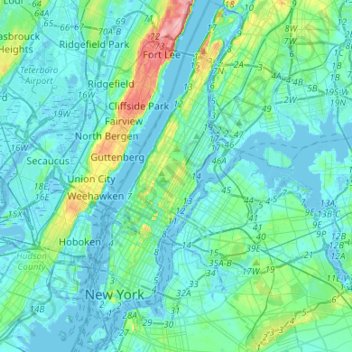
Nombre: Mapa topográfico New York County, altitud, relieve.
Lugar: New York County, New York, United States (40.67965 -74.04721 40.88201 -73.90677)
Altitud media: 16 m
Altitud mínima: -9 m
Altitud máxima: 117 m
Parkland covers a total of 2,659 acres (10.76 km2), accounting for 18.2% of the borough's land area; the 840-acre (3.4 km2) Central Park is the borough's largest park, comprising 31.6% of Manhattan's parkland. Designed by Frederick Law Olmsted and Calvert Vaux, the park is anchored by the 12-acre (4.9 ha) Great Lawn and offers extensive walking tracks, two ice-skating rinks, a wildlife sanctuary, and several lawns and sporting areas, as well as 21 playgrounds, and a 6-mile (9.7 km) road from which automobile traffic has been banned since 2018. While much of the park looks natural, it is almost entirely landscaped; the construction of Central Park in the 1850s was one of the era's most massive public works projects, with some 20,000 workers moving 5 million cubic yards (3.8 million cubic meters) of material to shape the topography and create the English-style pastoral landscape that Olmsted and Vaux sought.
Otros mapas topográficos
Haga clic en un mapa para ver su topografía, su altitud y su relieve.
Queens County
United States > New York > New York
Queens County, New York, United States
Altitud media: 11 m
Kings County
United States > New York > New York
Kings County, New York, United States
Altitud media: 9 m