
Haz una donación
Mapa topográfico Wayzata
Haga clic en el mapa para ver la altitud.
Haz una donación
Acerca de este mapa
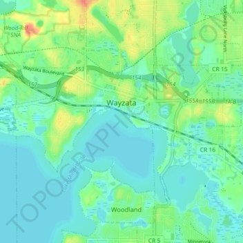
Nombre: Mapa topográfico Wayzata, altitud, relieve.
Lugar: Wayzata, Hennepin County, Minnesota, United States (44.95132 -93.54813 44.98223 -93.47671)
Altitud media: 291 m
Altitud mínima: 279 m
Altitud máxima: 323 m
Haz una donación
Otros mapas topográficos
Haga clic en un mapa para ver su topografía, su altitud y su relieve.
Pond-Dakota Mission Park
United States > Minnesota > Hennepin County > Bloomington
Altitud media: 235 m
Haz una donación
Elm Creek Park (Maple Grove Arboretum)
United States > Minnesota > Hennepin County > Maple Grove
Altitud media: 278 m
Mississippi River
United States > Minnesota > Hennepin County > Minneapolis
The uppermost lock and dam on the Upper Mississippi River is the Upper St. Anthony Falls Lock and Dam in Minneapolis. Above the dam, the river's elevation is 799 feet (244 m). Below the dam, the river's elevation is 750 feet (230 m). This 49-foot (15 m) drop is the largest of all the Mississippi River locks…
Altitud media: 256 m
Haz una donación
Minnehaha Falls
United States > Minnesota > Hennepin County > Minneapolis
Fortunately for the generations to come, in 1883 the state legislature created the Minneapolis Board of Park Commissioners. The board began by acquiring park land near today's downtown Minneapolis. Their choice to hire noted landscape architect Horace Cleveland was fortunate. Cleveland was hired by the Board…
Altitud media: 249 m
Haz una donación
Eden Prairie
United States > Minnesota > Hennepin County > Eden Prairie > Eden Prairie
Altitud media: 267 m
Haz una donación