
Gracias por apoyar a este sitio ❤️
Haz una donación
Haz una donación
Mapa topográfico Leinfelden
Haga clic en el mapa para ver la altitud.
Gracias por apoyar a este sitio ❤️
Haz una donación
Haz una donación
Acerca de este mapa
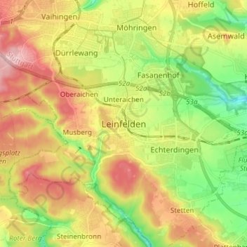
Nombre: Mapa topográfico Leinfelden, altitud, relieve.
Altitud media: 431 m
Altitud mínima: 347 m
Altitud máxima: 526 m
Gracias por apoyar a este sitio ❤️
Haz una donación
Haz una donación
Otros mapas topográficos
Haga clic en un mapa para ver su topografía, su altitud y su relieve.
Gracias por apoyar a este sitio ❤️
Haz una donación
Haz una donación
Gracias por apoyar a este sitio ❤️
Haz una donación
Haz una donación
Gracias por apoyar a este sitio ❤️
Haz una donación
Haz una donación
Lichtenwald
Germany > Baden-Württemberg > Landkreis Esslingen
The district of Hegenlohe lies on the wooded eastern slope (also called Heuberg by locals) of the Reichenbach valley and, like Thomashardt situated on the high ridge, is surrounded by the mixed forests of the Schurwald. The municipal area ranges from 342 to 480 meters in elevation.
Altitud media: 426 m
Gracias por apoyar a este sitio ❤️
Haz una donación
Haz una donación
Gracias por apoyar a este sitio ❤️
Haz una donación
Haz una donación
Gracias por apoyar a este sitio ❤️
Haz una donación
Haz una donación