
Haz una donación
Mapa topográfico Walesby Top
Haga clic en el mapa para ver la altitud.
Haz una donación
Acerca de este mapa
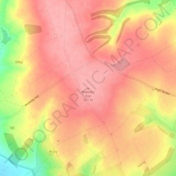
Nombre: Mapa topográfico Walesby Top, altitud, relieve.
Altitud media: 130 m
Altitud mínima: 49 m
Altitud máxima: 165 m
Haz una donación
Otros mapas topográficos
Haga clic en un mapa para ver su topografía, su altitud y su relieve.
Welton CP
United Kingdom > England > Lincolnshire > West Lindsey
The parish stretches from the ancient Ermine Street (A15) in the west, following a north-easterly shape to the Barlings Eau at its eastern end, of which the Welton Beck is a tributary, and is an example of a strip parish. Due to the low, flat topography of Lincolnshire, land had to be drained for agriculture…
Altitud media: 27 m
Haz una donación
Haz una donación
Haz una donación
Haz una donación
Haz una donación
Haz una donación
Haz una donación
Haz una donación
Haz una donación
Haz una donación
North Willingham CP
United Kingdom > England > Lincolnshire > West Lindsey > North Willingham CP
Altitud media: 82 m
Haz una donación
Corringham CP
United Kingdom > England > Lincolnshire > West Lindsey > Corringham CP
Altitud media: 21 m
Haz una donación
Haz una donación
Haz una donación