
Haz una donación
Mapa topográfico Frontenac
Haga clic en el mapa para ver la altitud.
Haz una donación
Acerca de este mapa
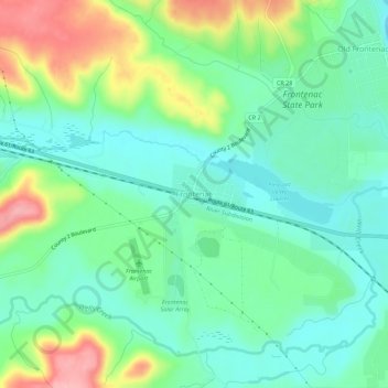
Nombre: Mapa topográfico Frontenac, altitud, relieve.
Altitud media: 243 m
Altitud mínima: 200 m
Altitud máxima: 338 m
Haz una donación
Otros mapas topográficos
Haga clic en un mapa para ver su topografía, su altitud y su relieve.
Haz una donación
Red Wing
United States > Minnesota > Goodhue County
According to the United States Census Bureau, the city has an area of 41.19 square miles (106.68 km2), of which 34.60 square miles (89.61 km2) is land and 6.59 square miles (17.07 km2) is water. The city is at the northern edge of the Driftless Area of karst topography.
Altitud media: 263 m