
Mapa topográfico Beyne-Heusay
Mapa interactivo
Haga clic en el mapa para ver la altitud.
Acerca de este mapa
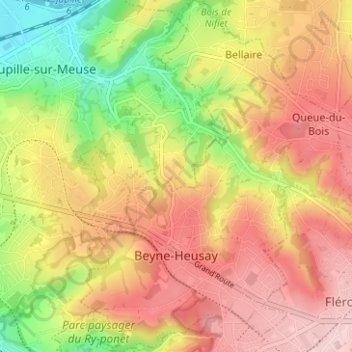
Nombre: Mapa topográfico Beyne-Heusay, altitud, relieve.
Lugar: Beyne-Heusay, Luik, Wallonië, 4610, België (50.61112 5.63549 50.65086 5.69361)
Altitud media: 175 m
Altitud mínima: 56 m
Altitud máxima: 268 m
Beyne-Heusay ligt in het Land van Herve op een hoogte van ongeveer 200 meter. De omgeving is sterk verstedelijkt, wat een gevolg is van de steenkoolwinning en de nabijheid van de Luikse agglomeratie. Enkele landgoedbossen, zoals Bois de Beyne, zijn echter nog aanwezig.
Otros mapas topográficos
Haga clic en un mapa para ver su topografía, su altitud y su relieve.
Villers-Saint-Siméon
België > Luik > Luik > Villers-Saint-Siméon
Villers-Saint-Siméon, Luik, Wallonië, 4453, België
Altitud media: 152 m
Grâce-Hollogne
België > Luik > Luik > Grâce-Hollogne
Grâce-Hollogne, Luik, Wallonië, 4460, België
Altitud media: 143 m
Remouchamps
België > Luik > Luik > Aywaille
Remouchamps, Aywaille, Luik, Wallonië, 4920, België
Altitud media: 222 m
Embourg
België > Luik > Luik > Chaudfontaine
Embourg, Chaudfontaine, Luik, Wallonië, 4050, België
Altitud media: 139 m
Rotheux-Rimière
België > Luik > Luik > Rotheux-Rimière
Rotheux-Rimière, Neupré, Luik, Wallonië, 4120, België
Altitud media: 233 m