
Mapa topográfico Dickie Lake
Mapa interactivo
Haga clic en el mapa para ver la altitud.
Acerca de este mapa
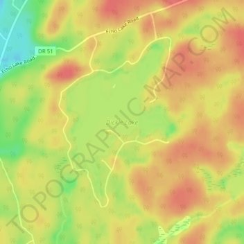
Nombre: Mapa topográfico Dickie Lake, altitud, relieve.
Altitud media: 360 m
Altitud mínima: 320 m
Altitud máxima: 383 m
Otros mapas topográficos
Haga clic en un mapa para ver su topografía, su altitud y su relieve.
Ril Lake
Canada > Ontario > Lake of Bays Township > Lake of Bays
Ril Lake, South Ril Lake Road, Lake of Bays Township, District Municipality of Muskoka, Muskoka District, Central Ontario, Ontario, Canada
Altitud media: 361 m
Oxbow Lake
Canada > Ontario > Lake of Bays
Oxbow Lake, East Oxbow Road, Lake of Bays, District Municipality of Muskoka, Muskoka District, Ontario, Canada
Altitud media: 400 m
Grant Lake
Canada > Ontario > Lake of Bays
Grant Lake, Shoe Lake Road, Lake of Bays, District Municipality of Muskoka, Muskoka District, Ontario, P0A 1E0, Canada
Altitud media: 384 m
Cream Lake
Canada > Ontario > Lake of Bays
Cream Lake, South Ril Lake Road, Lake of Bays, District Municipality of Muskoka, Muskoka District, Ontario, Canada
Altitud media: 363 m
Menominee Lake
Canada > Ontario > Lake of Bays
Menominee Lake, Grand Boulevard, Lake of Bays, District Municipality of Muskoka, Muskoka District, Ontario, Canada
Altitud media: 355 m
Dotty Lake
Canada > Ontario > Lake of Bays
Dotty Lake, Brookes Road, Lake of Bays, District Municipality of Muskoka, Muskoka District, Ontario, Canada
Altitud media: 403 m
Porcupine Lake
Canada > Ontario > Lake of Bays
Porcupine Lake, South Ril Lake Road, Lake of Bays, District Municipality of Muskoka, Muskoka District, Ontario, Canada
Altitud media: 361 m