
Mapa topográfico Feeny
Mapa interactivo
Haga clic en el mapa para ver la altitud.
Acerca de este mapa
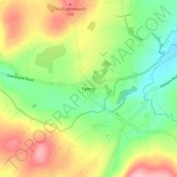
Nombre: Mapa topográfico Feeny, altitud, relieve.
Altitud media: 163 m
Altitud mínima: 87 m
Altitud máxima: 266 m
Otros mapas topográficos
Haga clic en un mapa para ver su topografía, su altitud y su relieve.
Derry/Londonderry
United Kingdom > Northern Ireland > County Londonderry
Derry/Londonderry, County Borough of Londonderry, County Londonderry, Northern Ireland, BT48 6BU, United Kingdom
Altitud media: 88 m
Portstewart
United Kingdom > Northern Ireland > County Londonderry
Portstewart, County Londonderry, Northern Ireland, BT55 7AG, United Kingdom
Altitud media: 13 m
Ballymaguigan
United Kingdom > Northern Ireland > County Londonderry
Ballymaguigan, County Londonderry, Northern Ireland, BT45 6LL, United Kingdom
Altitud media: 21 m
Ballymagroarty
United Kingdom > Northern Ireland > County Londonderry > Derry/Londonderry
Ballymagroarty, Hazelbank, Derry/Londonderry, County Londonderry, Northern Ireland, United Kingdom
Altitud media: 73 m
Desertmartin
United Kingdom > Northern Ireland > County Londonderry
Desertmartin, County Londonderry, Northern Ireland, BT45 5LD, United Kingdom
Altitud media: 63 m
Ballinderry
United Kingdom > Northern Ireland > County Londonderry
Ballinderry, County Londonderry, Northern Ireland, BT80 0BT, United Kingdom
Altitud media: 33 m
Gulladuff
United Kingdom > Northern Ireland > County Londonderry
Gulladuff, County Londonderry, Ulster, Northern Ireland, BT45 8PG, United Kingdom
Altitud media: 59 m
Straw
United Kingdom > Northern Ireland > County Londonderry
Straw, County Londonderry, Ulster, Northern Ireland, BT45 7BB, United Kingdom
Altitud media: 117 m
Upperlands
United Kingdom > Northern Ireland > County Londonderry
Upperlands, County Londonderry, Ulster, Northern Ireland, BT46 5SB, United Kingdom
Altitud media: 67 m
Magherafelt
United Kingdom > Northern Ireland > County Londonderry
Magherafelt, County Londonderry, Northern Ireland, BT45 6EE, United Kingdom
Altitud media: 59 m
Limavady
United Kingdom > Northern Ireland > County Londonderry
Limavady, County Londonderry, Northern Ireland, BT49 0EP, United Kingdom
Altitud media: 37 m
Dungiven
United Kingdom > Northern Ireland > County Londonderry
Dungiven, County Londonderry, Northern Ireland, BT47 4LE, United Kingdom
Altitud media: 140 m
Foreglen
United Kingdom > Northern Ireland > County Londonderry
Foreglen, County Londonderry, Ulster, Northern Ireland, BT47 4PJ, United Kingdom
Altitud media: 171 m
Coleraine
United Kingdom > Northern Ireland > County Londonderry
Coleraine, County Londonderry, Northern Ireland, BT52 1DP, United Kingdom
Altitud media: 40 m
Drumsurn
United Kingdom > Northern Ireland > County Londonderry
Drumsurn, County Londonderry, Northern Ireland, BT49 0PP, United Kingdom
Altitud media: 92 m
Draperstown
United Kingdom > Northern Ireland > County Londonderry
Draperstown, County Londonderry, Northern Ireland, BT45 7AD, United Kingdom
Altitud media: 96 m
Maghera
United Kingdom > Northern Ireland > County Londonderry
Maghera, County Londonderry, Northern Ireland, BT46 5AE, United Kingdom
Altitud media: 72 m
Claudy
United Kingdom > Northern Ireland > County Londonderry
Claudy, County Londonderry, Northern Ireland, BT47 4AA, United Kingdom
Altitud media: 126 m
Mullaghmore
United Kingdom > Northern Ireland > County Londonderry
Mullaghmore, County Londonderry, Ulster, Northern Ireland, BT45 7DZ, United Kingdom
Altitud media: 390 m
Lough Foyle
United Kingdom > Northern Ireland > County Londonderry > Londonderry/Derry
Lough Foyle, Londonderry/Derry, County Londonderry, Northern Ireland, United Kingdom
Altitud media: 61 m
Greysteel
United Kingdom > Northern Ireland > County Londonderry
Greysteel, County Londonderry, Northern Ireland, BT47 3DY, United Kingdom
Altitud media: 70 m
Sconce Hill
United Kingdom > Northern Ireland > County Londonderry
Sconce Hill, County Londonderry, Northern Ireland, BT51 4JS, United Kingdom
Altitud media: 158 m
Castledawson
United Kingdom > Northern Ireland > County Londonderry
Castledawson, County Londonderry, Northern Ireland, BT45 8AP, United Kingdom
Altitud media: 33 m
Slaughtneil
United Kingdom > Northern Ireland > County Londonderry > Slaughtneil
Slaughtneil, County Londonderry, Northern Ireland, BT46 5NH, United Kingdom
Altitud media: 136 m
Kilrea
United Kingdom > Northern Ireland > County Londonderry
Kilrea, County Londonderry, Northern Ireland, BT51 6SE, United Kingdom
Altitud media: 34 m
Castlerock
United Kingdom > Northern Ireland > County Londonderry
Castlerock, County Londonderry, Northern Ireland, BT51 4RA, United Kingdom
Altitud media: 23 m
Garvagh
United Kingdom > Northern Ireland > County Londonderry
Garvagh, County Londonderry, Ulster, Northern Ireland, BT51 5AE, United Kingdom
Altitud media: 93 m
Culmore
United Kingdom > Northern Ireland > County Londonderry
Culmore, County Londonderry, Ulster, Northern Ireland, BT48 8JN, United Kingdom
Altitud media: 22 m
Articlave
United Kingdom > Northern Ireland > County Londonderry
Articlave, County Londonderry, Ulster, Northern Ireland, BT51 4UR, United Kingdom
Altitud media: 48 m
Campsey
United Kingdom > Northern Ireland > County Londonderry > Londonderry/Derry
Campsey, Londonderry/Derry, County Londonderry, Northern Ireland, BT47 3PA, United Kingdom
Altitud media: 26 m
Moneymore
United Kingdom > Northern Ireland > County Londonderry
Moneymore, County Londonderry, Northern Ireland, BT45 7NG, United Kingdom
Altitud media: 71 m
Tobermore
United Kingdom > Northern Ireland > County Londonderry
Tobermore, County Londonderry, Ulster, Northern Ireland, BT45 5QB, United Kingdom
Altitud media: 54 m