
Gracias por apoyar a este sitio ❤️
Haz una donación
Haz una donación
Mapa topográfico Sonneberg
Haga clic en el mapa para ver la altitud.
Gracias por apoyar a este sitio ❤️
Haz una donación
Haz una donación
Sonneberg
"The Sonneberg Castle was also called Sonneberg Castle or the Haus zu Sonneberg in old documents. In 480 Süne or Süno, Duke of Franconia, built this castle because of the Thuringian incursions ..." so it says on page 64 in the topography of the Duke of Saxe-Meiningen's share in the Duchy of Coburg from the year 1781. This not uncritical representation is based on the history of the Franks by Abbot Johannes Trithemius from 1514.
Gracias por apoyar a este sitio ❤️
Haz una donación
Haz una donación
Acerca de este mapa
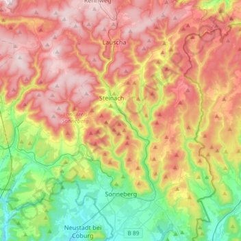
Nombre: Mapa topográfico Sonneberg, altitud, relieve.
Lugar: Sonneberg, Landkreis Sonneberg, Thuringia, 96515, Germany (50.32086 11.11405 50.50751 11.28479)
Altitud media: 586 m
Altitud mínima: 327 m
Altitud máxima: 866 m
Gracias por apoyar a este sitio ❤️
Haz una donación
Haz una donación