
Gracias por apoyar a este sitio ❤️
Haz una donación
Haz una donación
Mapa topográfico Burbank
Haga clic en el mapa para ver la altitud.
Gracias por apoyar a este sitio ❤️
Haz una donación
Haz una donación
Burbank
Elevations in the city range from 500 feet (150 m) in the lower valley areas to about 800 feet (240 m) near the Verdugo Mountains. Most of Burbank features a water table more than 100 feet (30 m) deep, more than the measures found in the 1940s when the water table was within 50 feet (15 m) of the ground surface in some areas of Burbank.
Gracias por apoyar a este sitio ❤️
Haz una donación
Haz una donación
Acerca de este mapa
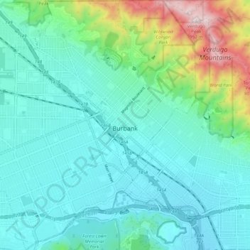
Nombre: Mapa topográfico Burbank, altitud, relieve.
Lugar: Burbank, Los Angeles County, California, United States (34.14266 -118.37017 34.22165 -118.28003)
Altitud media: 251 m
Altitud mínima: 128 m
Altitud máxima: 947 m
Gracias por apoyar a este sitio ❤️
Haz una donación
Haz una donación