
Mapa topográfico Anogia
Mapa interactivo
Haga clic en el mapa para ver la altitud.
Acerca de este mapa
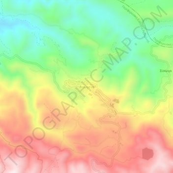
Nombre: Mapa topográfico Anogia, altitud, relieve.
Altitud media: 713 m
Altitud mínima: 420 m
Altitud máxima: 1.030 m
The historian Stelios Spanakis, summarily provides geographical, as well as historical information about Anogia,: “Anogia is a town –municipality in the Mylopotamos Province of the Prefecture of Rethymno. In the 1981 census it numbered 2.449 citizens. It is in the northern reaches of Psiloreitis, at an altitude of 700-790 meters. When in 1182 Crete was divided among the 12 Young Princes of Byzantium, Anogia were given to the family of Fokas. Anogia are referred to by Venetian and Greek scholars and historians as Anogia, or Anoia. In 1593 it was already a significant settlement, numbering 911 citizens. Anogia are referred to as a revolutionary place during the years of Turkish occupation. In 1822, when the Anogians were fighting the Turks in Messara, Serif Pasha found the village empty and put it to the torch. In November 1866, during the Great Cretan Revolt, Resit Pasha tried to capture Anogia, but he was repulsed by the Anogians and other villagers from Mylopotamos.” This tradition continued during the German occupation and in August 1944 the village was once again razed to the ground in reprisal for the local's participation in the resistance.
Otros mapas topográficos
Haga clic en un mapa para ver su topografía, su altitud y su relieve.
Myli Gorge
Greece > Region of Crete > Rethymno Regional Unit > Xiro Chorio > Myli
Myli Gorge, Myli, Xiro Chorio, Municipality of Rethymnon, Rethymno Regional Unit, Region of Crete, 741 00, Greece
Altitud media: 198 m
Zoniana
Greece > Region of Crete > Rethymno Regional Unit
Zoniana, Municipality of Milopotamos, Rethymno Regional Unit, Region of Crete, 740 51, Greece
Altitud media: 691 m