
Gracias por apoyar a este sitio ❤️
Haz una donación
Haz una donación
Mapa topográfico Mto wa Mbu
Haga clic en el mapa para ver la altitud.
Gracias por apoyar a este sitio ❤️
Haz una donación
Haz una donación
Acerca de este mapa
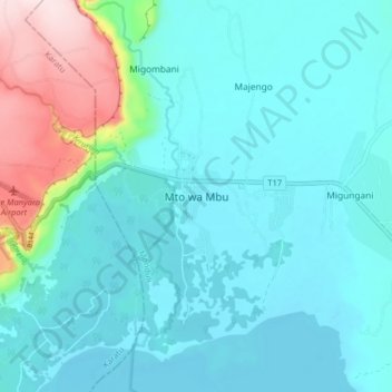
Nombre: Mapa topográfico Mto wa Mbu, altitud, relieve.
Lugar: Mto wa Mbu, Monduli, Arusha, Northern Zone, Tanzania (-3.41671 35.81580 -3.33671 35.89580)
Altitud media: 1.019 m
Altitud mínima: 951 m
Altitud máxima: 1.344 m
Gracias por apoyar a este sitio ❤️
Haz una donación
Haz una donación
Otros mapas topográficos
Haga clic en un mapa para ver su topografía, su altitud y su relieve.
Karatu
Karatu District (Wilaya ya Karatu, in Swahili) is one of seven districts of the Arusha Region of Tanzania. The district is bordered to the north by the Ngorongoro District and to the west by the Meatu District in the Simiyu Region. The district is bordered to the east by the Monduli District, and to the south…
Altitud media: 1.468 m
Gracias por apoyar a este sitio ❤️
Haz una donación
Haz una donación