
Haz una donación
Mapa topográfico Lamia Municipality
Haga clic en el mapa para ver la altitud.
Haz una donación
Acerca de este mapa
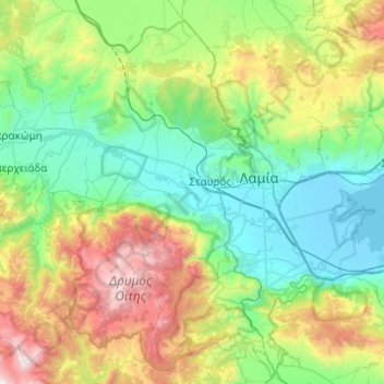
Nombre: Mapa topográfico Lamia Municipality, altitud, relieve.
Altitud media: 611 m
Altitud mínima: -4 m
Altitud máxima: 2.264 m
Haz una donación
Otros mapas topográficos
Haga clic en un mapa para ver su topografía, su altitud y su relieve.
Domokos
Greece > Thessaly and Central Greece > Phthiotis Regional Unit > Δημοτική Ενότητα Δομοκού
Altitud media: 440 m
Haz una donación
Kalypso
Greece > Thessaly and Central Greece > Phthiotis Regional Unit > Municipal Unit of Dafnousia
Altitud media: 54 m
Sarantaina
Greece > Thessaly and Central Greece > Phthiotis Regional Unit > Municipal Unit of Sperchiada
Altitud media: 1.660 m
Kallidromo
Greece > Thessaly and Central Greece > Phthiotis Regional Unit > Municipal Unit of Molos
Altitud media: 356 m
Stavros
Greece > Thessaly and Central Greece > Phthiotis Regional Unit > Municipal Unit of Lamia
Altitud media: 84 m
Haz una donación
Loutra Thermopilon
Greece > Thessaly and Central Greece > Phthiotis Regional Unit > Municipal Unit of Lamia
Altitud media: 241 m
Παρνασσός
Greece > Thessaly and Central Greece > Phthiotis Regional Unit > Municipal Unit of Tithorea
Altitud media: 2.125 m