
Mapa topográfico Victor
Mapa interactivo
Haga clic en el mapa para ver la altitud.
Acerca de este mapa
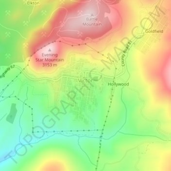
Nombre: Mapa topográfico Victor, altitud, relieve.
Lugar: Victor, Teller County, Colorado, United States (38.70404 -105.14716 38.71428 -105.13556)
Altitud media: 2.974 m
Altitud mínima: 2.803 m
Altitud máxima: 3.160 m
In 2022, youtubers The Baseball Bat Bros attempted to break the Guinness World Record for Longest home run hit, set by Babe Ruth in 1921 with a verified measurement of 575 feet. The attempt was made at The Gold Bowl baseball and soccer field. Victor, having one of the highest elevations in the United States was an ideal location as thinner air at high elevations creates less drag on a traveling baseball than at lower elevations, thus allowing it to travel farther in the air. Various high school, college, and former professional baseball players were invited to attempt to break the record but none were successful with elevated land beyond the outfield and unfavorable winds likely spoiling the attempts. The longest home run hit on the day was an estimated 534 feet.
Otros mapas topográficos
Haga clic en un mapa para ver su topografía, su altitud y su relieve.
Woodland Park
United States > Colorado > Teller County
Woodland Park, Teller County, Colorado, 80863, United States
Altitud media: 2.652 m
Midland
United States > Colorado > Teller County
Midland, Teller County, Colorado, United States
Altitud media: 2.874 m
Cripple Creek
United States > Colorado > Teller County
Cripple Creek, Teller County, Colorado, United States
Altitud media: 2.946 m
Florissant
United States > Colorado > Teller County
Florissant, Teller County, Colorado, United States
Altitud media: 2.556 m
Divide
United States > Colorado > Teller County
Divide, Teller County, Colorado, United States
Altitud media: 2.796 m
Woodland Park
United States > Colorado > Teller County > Woodland Park
Woodland Park, Teller County, Colorado, 80863, United States
Altitud media: 2.657 m
Copper Mountain
United States > Colorado > Teller County
Copper Mountain, Teller County, Colorado, 80813, United States
Altitud media: 2.946 m
Squaw Mountain
United States > Colorado > Teller County
Squaw Mountain, Teller County, Colorado, 80860, United States
Altitud media: 2.977 m