

Haz una donación
Mapa topográfico Sikkim
Haga clic en el mapa para ver la altitud.
Haz una donación
Sikkim
Situated in the Himalayan mountains, the state of Sikkim is characterised by mountainous terrain. Almost the entire state is hilly, with an elevation ranging from 280 metres (920 ft) in the south at the border with West Bengal to 8,586 metres (28,169 ft) in northern peaks near Nepal and Tibet. The summit of Kangchenjunga, the world's third-highest peak, is the state's highest point, situated on the border between Sikkim and Nepal. For the most part, the land is unfit for agriculture because of the rocky, precipitous slopes. However, some hill slopes have been converted into terrace farms.
Haz una donación
Acerca de este mapa
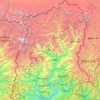
Nombre: Mapa topográfico Sikkim, altitud, relieve.
Lugar: Sikkim, India (27.07926 88.01203 28.12405 88.92117)
Altitud media: 3.786 m
Altitud mínima: 264 m
Altitud máxima: 8.434 m
Haz una donación
Otros mapas topográficos
Haga clic en un mapa para ver su topografía, su altitud y su relieve.
Leh
Leh (/ˈlɛ/) (Ladakhi: གླེ) is the joint capital and largest city of Ladakh, a union territory of India. Leh, located in the Leh district, was also the historical capital of the Kingdom of Ladakh, the seat of which was in the Leh Palace, the former residence of the royal family of Ladakh, built in the…
Altitud media: 4.294 m
Salem
Salem is located at 11°40′N 78°08′E / 11.67°N 78.14°E / 11.67; 78.14, at an average elevation of 278 m (912 ft). The city is surrounded by hills: Nagaramalai on the north, Jarugumalai on the south, Kanjamalai on the west, Godumalai on the east and the Shevaroy Hills on the northeast.…
Altitud media: 418 m

Haz una donación
Mysuru
India > Karnataka > Mysuru taluk
Mysore (/maɪˈsɔːr/ (listen)), officially Mysuru ([ˈmaɪˈsuːɾu] (listen)), is a city in the southern part of the state of Karnataka, India. Mysore city is geographically located between 12° 18′ 26″ north latitude and 76° 38′ 59″ east longitude. It is located at an altitude of 770 m (2,530 ft)…
Altitud media: 727 m
Bhubaneshwar
India > Odisha > Bhubaneswar (M.Corp.)
Bhubaneswar is in Khordha district of Odisha. It is in the eastern coastal plains, along the axis of the Eastern Ghats mountains. The city has an average altitude of 45 m (148 ft) above sea level. It lies southwest of the Mahanadi River that forms the northern boundary of Bhubaneswar metropolitan area, within…
Altitud media: 30 m
Vadodara
India > Gujarat > Vadodara Rural Taluka
Vadodara is located at 22°18′N 73°11′E / 22.30°N 73.19°E / 22.30; 73.19 in western India at an elevation of 39 metres (128 ft). It is the tenth-largest city in India with an area of 400 square kilometres (150 sq mi) and a population of 3.5 million, according to the 2010–11 census. The city…
Altitud media: 36 m
Haz una donación
Thrissur
Thrissur is the headquarters of Thrissur district, in the centre of the Indian state of Kerala. The city is 75 km north-east of Kochi, 133 km south-west of Coimbatore, 124 km south-east of Kozhikode and 151 km north of Changanacherry. The city is located in a hillock called Thekkinkadu Maidan which is the…
Altitud media: 36 m
Dehradun
India > Uttarakhand > Dehradun
The city of Dehradun mainly lies in Doon Valley and is at a varying height from 410 m (1,350 ft) in Clement Town to above 700 m (2,300 ft) at Malsi which is 15 km (9.3 mi) from the city. However, the average elevation is 450 m (1,480 ft) above sea level. Malsi is the starting point of Lesser Himalayan Range…
Altitud media: 904 m

Haz una donación


Dharamshala
India > Himachal Pradesh > Dharamshala
Dharamshala has an average elevation of 1,457 m (4,780 ft), covering an area of almost 8.51 km2 (3.29 sq mi). Dharamsala is located in the Kangra Valley, in the shadow of the Dhauladhar mountains.
Altitud media: 1.781 m
Haz una donación
Western Ghats
The range starts near south of the Tapti river and runs approximately 1,600 km (990 mi) through the states of Gujarat, Maharashtra, Karnataka, Goa, Kerala and Tamil Nadu ending at Marunthuvazh Malai, Swamithope near the southern tip of India. These hills cover 160,000 km2 (62,000 sq mi) and form the catchment…
Altitud media: 2.225 m
Mumbai
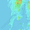
Mumbai lies at the mouth of the Ulhas River on the western coast of India, in the coastal region known as the Konkan. It sits on Salsette Island (Sashti Island), which it partially shares with the Thane district. Mumbai is bounded by the Arabian Sea to the west. Many parts of the city lie just above sea level,…
Altitud media: 13 m
Haz una donación


Chittorgarh Fort
India > Rajasthan > Chittaurgarh Tehsil > Chittauri > Chittauri Ka Khera
Altitud media: 427 m
Haz una donación



Maharashtra
Maharashtra is the third largest state by area in India. The Western Ghats better known as Sahyadri, are a hilly range running parallel to the coast, at an average elevation of 1,200 metres (4,000 ft). Kalsubai, a peak in the Sahyadris, near Nashik city is the highest elevated point in Maharashtra. To the west…
Altitud media: 478 m
Haz una donación

Rajamahendravaram
India > Andhra Pradesh > Rajahmundry (Urban)
Rajahmundry is located at 16°59′N 81°47′E / 16.98°N 81.78°E / 16.98; 81.78. with an average elevation of 14 metres (46 ft). It is geographically located at centre of Godavari Districts.There is paddy, sugarcane and various varieties of flowers cultivation in the area. River Godavari flows…
Altitud media: 29 m


Haz una donación


Haz una donación

Haz una donación
Dehradun
India > Uttarakhand > Dehradun
The city of Dehradun mainly lies in Doon Valley and is at a varying height from 410 m (1,350 ft) in Clement Town to above 700 m (2,300 ft) at Malsi which is 15 km (9.3 mi) from the city. However, the average elevation is 450 m (1,480 ft) above sea level. Malsi is the starting point of Lesser Himalayan Range…
Altitud media: 904 m
Haz una donación
Srinagar
India > Jammu and Kashmir > Srinagar (South)
Under the Köppen climate classification, Srinagar has a four-season humid subtropical climate (Cfa) with hot summers and cool winters. The valley is surrounded by the Himalayas on all sides. Due to influence from Himalayan rain shadow and western disturbances, Srinagar has year-round precipitation; the spring…
Altitud media: 1.805 m
Lucknow
India > Uttar Pradesh > Lucknow
Lucknow stands at an elevation of approximately 123 metres (404 ft) above sea level. The city had an area of 402 km2 (155 square miles) until December 2019, when 88 villages were added to the municipal limits and the area increased to 631 km2 (244 square miles). Bounded on the east by Barabanki, on the west by…
Altitud media: 120 m


Haz una donación



Haz una donación
Thiruvananthapuram
India > Kerala > Thiruvananthapuram
Thiruvananthapuram is built on seven hills by the seashore and is at 8°30′N 76°54′E / 8.5°N 76.9°E / 8.5; 76.9 on the west coast, near the southern tip of mainland India. The city is on the west coast of India and is bounded by the Laccadive Sea to its west and the Western Ghats to its east.…
Altitud media: 33 m
Vijayawada
India > Andhra Pradesh > Vijayawada (Urban)
Vijayawada lies on the banks of Krishna river, covered by hills and canals. and at an altitude of 11 m (36 ft) above sea level. Three canals originating from the north side of the Prakasam Barrage reservoir — Eluru, Bandar, and Ryves — flow through the city.
Altitud media: 37 m
Haz una donación

Madurai
India > Tamil Nadu > Madurai
Madurai is located at 9°56′N 78°07′E / 9.93°N 78.12°E / 9.93; 78.12. It has an average elevation of 101 metres. The city of Madurai lies on the flat and fertile plain of the river Vaigai, which runs in the northwest-southeast direction through the city, dividing it into two almost equal…
Altitud media: 138 m

Haz una donación



Haz una donación


Haz una donación


Haz una donación

Haz una donación
Karimpur
India > West Bengal > Karimpur-I
Karimpur is located at 23°58′N 88°37′E / 23.97°N 88.62°E / 23.97; 88.62. It has an average elevation of 15 metres (49 ft). It is 183 km (114 mi) from Kolkata and is located at the bank of the River Jalangi.
Altitud media: 18 m

Haz una donación


Haz una donación
Vadodara
India > Gujarat > Vadodara Rural Taluka
Vadodara is located at 22°18′N 73°11′E / 22.30°N 73.19°E / 22.30; 73.19 in western India at an elevation of 39 metres (128 ft). It is the tenth-largest city in India with an area of 400 square kilometres (150 sq mi) and a population of 3.5 million, according to the 2010–11 census. The city…
Altitud media: 36 m
Guwahati
Professor Abani Kumar Bhagawati of Gauhati University stated that since before there were sufficient wetlands to absorb rainwater and channels to carry excess water to the Brahmaputra, the city did not experience floods. However, human interference has disrupted the natural topography, leading to the current…
Altitud media: 113 m
Haz una donación

Kurnool
India > Andhra Pradesh > Kurnool
Kurnool is located at 15°50′00″N 78°03′00″E / 15.8333°N 78.05°E / 15.8333; 78.05. It has an average elevation of 273 metres (898 feet). Kurnool lies on the banks of the Tungabhadra River. The Hundri and Neeva rivers also flow through the city. The K.C.Canal (Kurnool–Cuddapah) was built…
Altitud media: 307 m
Bhubaneshwar
India > Odisha > Bhubaneswar (M.Corp.)
Bhubaneswar is in Khordha district of Odisha. It is in the eastern coastal plains, along the axis of the Eastern Ghats mountains. The city has an average altitude of 45 m (148 ft) above sea level. It lies southwest of the Mahanadi River that forms the northern boundary of Bhubaneswar metropolitan area, within…
Altitud media: 30 m


Haz una donación


Haz una donación

Dandeli
India > Karnataka > Dandeli taluku
Dandeli is located at 15°16′01″N 74°37′01″E / 15.267°N 74.617°E / 15.267; 74.617. It has an average elevation of 473 metres (1,552 ft) and has received heavy rainfall during August to November (see chart below). Because of good forest cover and moderate elevation, the location has a…
Altitud media: 480 m


Gulmarg
India > Jammu and Kashmir > Tangmarg
Gulmarg (also known as Gulmarag, lit. 'meadow of flowers' in Kashmiri) is a hill station and a notified area committee in Baramulla district of the Indian union territory of Jammu and Kashmir. It is located in the Indian administered Kashmir, close to the Line of Control that serves as the de facto border…
Altitud media: 2.590 m
Haz una donación