
Mapa topográfico St. Helier
Mapa interactivo
Haga clic en el mapa para ver la altitud.
St. Helier
The topography of the parish is one of the most varied. The marshland on which the town is situated is encircled by highlands which protect the town from the worst winds. In the southeast of the parish, rising from the plains in the centre of town, there is also Mont de Ville. This divides the Havre des Pas district from the Harbour.
Acerca de este mapa
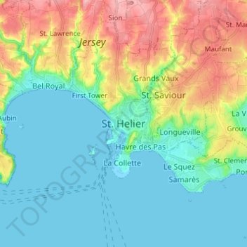
Nombre: Mapa topográfico St. Helier, altitud, relieve.
Lugar: St. Helier, JE4 8PA, Jersey (49.14566 -2.15023 49.22566 -2.07023)
Altitud media: 32 m
Altitud mínima: -2 m
Altitud máxima: 108 m