
Mapa topográfico Harrah
Mapa interactivo
Haga clic en el mapa para ver la altitud.
Acerca de este mapa
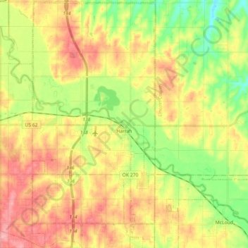
Nombre: Mapa topográfico Harrah, altitud, relieve.
Lugar: Harrah, Oklahoma County, Oklahoma, United States of America (35.42050 -97.23034 35.56635 -97.14076)
Altitud media: 342 m
Altitud mínima: 294 m
Altitud máxima: 389 m
Harrah is a small city in Oklahoma with a total land area of 11.9 square miles (31 km2) and no water. The city's elevation is 925 feet (282 m) above sea level. It lies partly in the Great Plains near the geographical center of the 48 contiguous states in the United States. It lies between the larger cities of Oklahoma City to the west and Shawnee, Oklahoma, to the east, in Oklahoma County.