
Mapa topográfico Morgantown
Mapa interactivo
Haga clic en el mapa para ver la altitud.
Acerca de este mapa
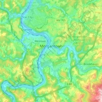
Nombre: Mapa topográfico Morgantown, altitud, relieve.
Lugar: Morgantown, Monongalia County, West Virginia, United States (39.57431 -79.98816 39.67510 -79.89877)
Altitud media: 337 m
Altitud mínima: 241 m
Altitud máxima: 581 m
During the 1970s, the U.S. Department of Transportation built an experimental driverless personal rapid transit system in the city, citing the area's variable seasonal climate and geographic elevations as factors in testing the technology's viability. The Morgantown Personal Rapid Transit (PRT) has been in use since 1975. University students use the system for free travel between the campuses.