
Gracias por apoyar a este sitio ❤️
Haz una donación
Haz una donación
Mapa topográfico Untertürkheim
Haga clic en el mapa para ver la altitud.
Gracias por apoyar a este sitio ❤️
Haz una donación
Haz una donación
Acerca de este mapa
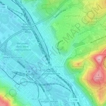
Nombre: Mapa topográfico Untertürkheim, altitud, relieve.
Lugar: Untertürkheim, Stuttgart, Baden-Württemberg, 70327, Germany (48.77115 9.23980 48.79618 9.26918)
Altitud media: 261 m
Altitud mínima: 217 m
Altitud máxima: 402 m
Gracias por apoyar a este sitio ❤️
Haz una donación
Haz una donación
Otros mapas topográficos
Haga clic en un mapa para ver su topografía, su altitud y su relieve.
Stuttgart
Germany > Baden-Württemberg > Stuttgart
Stuttgart covers an area of 207.35 km2 (80 sq mi) and sits at elevation ranging from 207 m (679 ft) above sea level by the Neckar river to 549 m (1,801 ft) on Bernhartshöhe hill – something rather unique in large German cities. The most prominent elevated locales in Stuttgart are the Birkenkopf (511 m…
Altitud media: 353 m