
Haz una donación
Mapa topográfico Neuses an der Regnitz
Haga clic en el mapa para ver la altitud.
Haz una donación
Acerca de este mapa
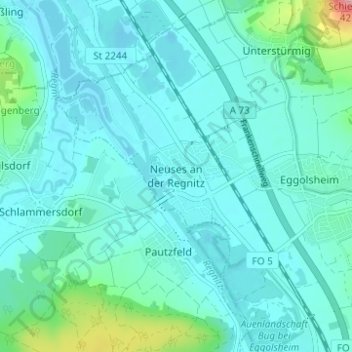
Nombre: Mapa topográfico Neuses an der Regnitz, altitud, relieve.
Altitud media: 266 m
Altitud mínima: 245 m
Altitud máxima: 393 m
Haz una donación
Otros mapas topográficos
Haga clic en un mapa para ver su topografía, su altitud y su relieve.
Forchheim
Germany > Bavaria > Landkreis Forchheim
Forchheim (German pronunciation: [ˈfɔʁçhæɪ̯m] ) is a town in Upper Franconia (German: Oberfranken) in northern Bavaria, and also the seat of the administrative district of Forchheim. Forchheim is a former royal city, and is sometimes called the Gateway to the Franconian Switzerland, referring to the…
Altitud media: 299 m
Gräfenberg
Germany > Bavaria > Landkreis Forchheim
Gräfenberg is located in the southern part of Little Switzerland. The town is characterised by a great range of elevation (from 400 to 550 metres). A brook, the Kalkach, flows through the town with a steep drop.
Altitud media: 468 m
Haz una donación
Haz una donación
Haz una donación