
Haz una donación
Mapa topográfico Muncho Lake
Haga clic en el mapa para ver la altitud.
Haz una donación
Muncho Lake
The lake is part of the Muncho Lake Provincial Park and located at kilometre 681 (mile 423) of the Alaska Highway. The lake is about 12 km (7.5 mi) long and its width varies. It reaches a maximum depth of 110 m (360 ft). The surrounding peaks (the Terminal Range of the Muskwa Ranges to the west and the Sentinel Range to the east) reach altitudes of more than 2,000 m (6,600 ft), while the lake lies at an elevation of 820 m (2,690 ft). It is formed along the Trout River, a tributary of the Liard River.
Haz una donación
Acerca de este mapa
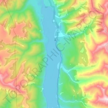
Nombre: Mapa topográfico Muncho Lake, altitud, relieve.
Altitud media: 1.322 m
Altitud mínima: 817 m
Altitud máxima: 2.235 m
Haz una donación
Otros mapas topográficos
Haga clic en un mapa para ver su topografía, su altitud y su relieve.
Rocky Mountains
Canada > British Columbia > Northern Rockies Regional Municipality
Altitud media: 1.329 m
Haz una donación
Haz una donación