
Haz una donación
Mapa topográfico Zuffenhausen
Haga clic en el mapa para ver la altitud.
Haz una donación
Zuffenhausen
Zuffenhausen's terrain, a river valley carved into existence by the Feuerbach river, has two distinct elevations: Zuffenhausen with an average of 255 m (837 ft) and Zazenhausen at 252 m (827 ft). To the north and northwest are the vast stretches of the Langes Feld rolling hills on a height of over 300 m (980 ft) that peak at 327 m (1,073 ft) near Neuwirtshaus, an area that constitutes the eastern Strohgäu, a rich farmland largely free of trees. To the south are the Stuttgart Mountains and the Neckar valley to the east, followed by the Schurwald mountains. Irregular ascents are characteristic for the Zuffenhausen region, of which Burgholzhof is the highest at 359 m (1,178 ft) above sea level.
Haz una donación
Acerca de este mapa
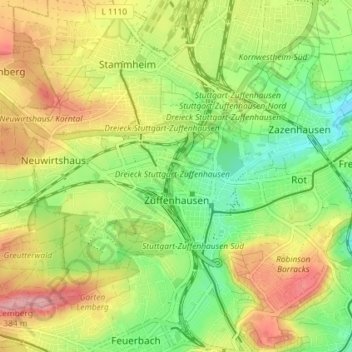
Nombre: Mapa topográfico Zuffenhausen, altitud, relieve.
Lugar: Zuffenhausen, Stuttgart, Baden-Württemberg, Germany (48.81754 9.13709 48.85155 9.20962)
Altitud media: 301 m
Altitud mínima: 237 m
Altitud máxima: 379 m
Haz una donación
Otros mapas topográficos
Haga clic en un mapa para ver su topografía, su altitud y su relieve.
Stuttgart
Germany > Baden-Württemberg > Stuttgart
Stuttgart covers an area of 207.35 km2 (80 sq mi) and sits at elevation ranging from 207 m (679 ft) above sea level by the Neckar river to 549 m (1,801 ft) on Bernhartshöhe hill – something rather unique in large German cities. The most prominent elevated locales in Stuttgart are the Birkenkopf (511 m…
Altitud media: 353 m