
Haz una donación
Mapa topográfico Calverton CP
Haga clic en el mapa para ver la altitud.
Haz una donación
Acerca de este mapa
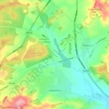
Nombre: Mapa topográfico Calverton CP, altitud, relieve.
Altitud media: 81 m
Altitud mínima: 33 m
Altitud máxima: 163 m
Haz una donación
Otros mapas topográficos
Haga clic en un mapa para ver su topografía, su altitud y su relieve.
Arnold
United Kingdom > England > Nottinghamshire > Gedling
The local topography suggests that Arnold can never have been a haunt of eagles, because they inhabit areas of rocky outcrops, which have formed cliffs: the nearest such location is Creswell Crags, some 20 miles (32 km) north-west as the eagle flies. However, the fish-eating white-tailed eagle (also known as…
Altitud media: 81 m
Gedling Country Park
United Kingdom > England > Nottinghamshire > Gedling > Carlton
Altitud media: 80 m
Haz una donación
Colwick Country Park
United Kingdom > England > Nottinghamshire > Gedling > Carlton > Colwick
Altitud media: 32 m
Lambley Lane Recreation Ground (North)
United Kingdom > England > Nottinghamshire > Gedling > Carlton
Altitud media: 73 m