
Mapa topográfico Le Culot
Mapa interactivo
Haga clic en el mapa para ver la altitud.
Acerca de este mapa
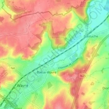
Nombre: Mapa topográfico Le Culot, altitud, relieve.
Altitud media: 71 m
Altitud mínima: 28 m
Altitud máxima: 108 m
Otros mapas topográficos
Haga clic en un mapa para ver su topografía, su altitud y su relieve.
Louvrange
Belgique > Brabant wallon > Nivelles > Wavre
Louvrange, Wavre, Nivelles, Brabant wallon, Wallonie, 1348, Belgique
Altitud media: 107 m
Basse-Wavre
Belgique > Brabant wallon > Nivelles > Wavre
Basse-Wavre, Wavre, Nivelles, Brabant wallon, Wallonie, 1300, Belgique
Altitud media: 74 m
Limal
Belgique > Brabant wallon > Nivelles > Wavre
Limal, Wavre, Nivelles, Brabant wallon, Wallonie, 1302, Belgique
Altitud media: 86 m