
Gracias por apoyar a este sitio ❤️
Haz una donación
Haz una donación
Mapa topográfico Monviso
Haga clic en el mapa para ver la altitud.
Gracias por apoyar a este sitio ❤️
Haz una donación
Haz una donación
Monviso
Monte Viso is the location of a neolithic jadeite quarry, at an elevation of 2,000 to 2,400 metres. Its productivity peaked around 5000 BC. The jadeite was used to make cult axes, which are found all over western Europe. One such ceremonial axe head was found as far away as a small hill called Tristia in Western Ireland and is on display in the National Museum of Ireland – Archaeology, Dublin.
Gracias por apoyar a este sitio ❤️
Haz una donación
Haz una donación
Acerca de este mapa
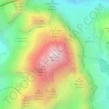
Nombre: Mapa topográfico Monviso, altitud, relieve.
Lugar: Monviso, Pontechianale, Cuneo, Piedmont, Italy (44.66739 7.08994 44.66749 7.09004)
Altitud media: 2.985 m
Altitud mínima: 2.385 m
Altitud máxima: 3.831 m
Gracias por apoyar a este sitio ❤️
Haz una donación
Haz una donación