
Haz una donación
Mapa topográfico Bramshall
Haga clic en el mapa para ver la altitud.
Haz una donación
Acerca de este mapa
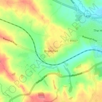
Nombre: Mapa topográfico Bramshall, altitud, relieve.
Altitud media: 121 m
Altitud mínima: 86 m
Altitud máxima: 165 m
Haz una donación
Otros mapas topográficos
Haga clic en un mapa para ver su topografía, su altitud y su relieve.
Tutbury Castle
United Kingdom > England > Staffordshire > East Staffordshire > Tutbury
Altitud media: 66 m
Barton-under-Needwood
United Kingdom > England > Staffordshire > East Staffordshire > Barton-under-Needwood
Altitud media: 69 m
Haz una donación
Draycott in the Clay
United Kingdom > England > Staffordshire > East Staffordshire
Altitud media: 90 m
Blithfield Reservoir
United Kingdom > England > Staffordshire > East Staffordshire > Admaston
Altitud media: 108 m
Shobnall
United Kingdom > England > Staffordshire > East Staffordshire > Burton-on-Trent
Altitud media: 56 m
Haz una donación
Mayfield
United Kingdom > England > Staffordshire > East Staffordshire > Mayfield
Altitud media: 156 m
Haz una donación
Haz una donación
Hanbury
United Kingdom > England > Staffordshire > East Staffordshire
This locality adjoins the River Dove and includes a steep knoll between much of it and the river, Row Hill; five listed buildings are here all at Grade II. Hanbury's village centre is 0.9 miles (1.4 km) to the south. This hamlet is at an elevation of 61m AOD whereas the village centre of Hanbury is at the…
Altitud media: 107 m
Haz una donación
Harlow Wood
United Kingdom > England > Staffordshire > East Staffordshire > Upper Mayfield
Altitud media: 177 m
Haz una donación