
Mapa topográfico Sikkim
Mapa interactivo
Haga clic en el mapa para ver la altitud.
Acerca de este mapa
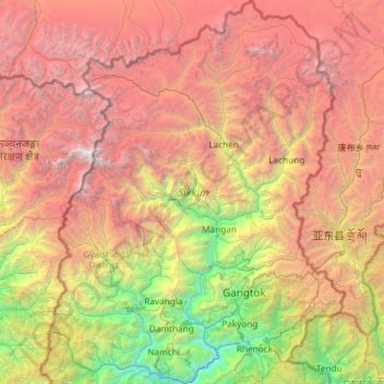
Nombre: Mapa topográfico Sikkim, altitud, relieve.
Lugar: Sikkim, India (27.07940 88.01203 28.12264 88.92137)
Altitud media: 3.786 m
Altitud mínima: 264 m
Altitud máxima: 8.447 m
Situated in the Himalayan mountains, the state of Sikkim is characterised by mountainous terrain. Almost the entire state is hilly, with an elevation ranging from 280 metres (920 ft) in the south at the border with West Bengal to 8,586 metres (28,169 ft) in northern peaks near Nepal and Tibet. The summit of Kangchenjunga, the world's third-highest peak, is the state's highest point, situated on the border between Sikkim and Nepal. For the most part, the land is unfit for agriculture because of the rocky, precipitous slopes. However, some hill slopes have been converted into terrace farms.
Otros mapas topográficos
Haga clic en un mapa para ver su topografía, su altitud y su relieve.
Bengaluru
India > Karnataka > Bangalore North
Bengaluru, Bangalore North, Bengaluru Urban District, Karnataka, India
Altitud media: 881 m
3d
India > Rajasthan > Ganganagar Tehsil > 1 LNP
3d, 1 LNP, Ganganagar Tehsil, Sri Ganganagar District, Rajasthan, India
Altitud media: 178 m
Mysuru
India > Karnataka > Mysuru taluk
Mysuru, Mysuru taluk, Mysuru District, Karnataka, 570001, India
Altitud media: 727 m
Patna
India > Bihar > Patna Rural
Patna, Patna Rural, Patna District, Bihar, 800001, India
Altitud media: 51 m
Pune
India > Maharashtra > Pune City > Pune
Pune, Pune City, Pune District, Maharashtra, 411001, India
Altitud media: 641 m
Kriti
India > Jammu and Kashmir > Kokernag Tehsil
Kriti, Kokernag Tehsil, Anantnag District, Jammu and Kashmir, India
Altitud media: 2.288 m
Bachupally mandal
Bachupally mandal, Medchal–Malkajgiri District, Telangana, 500090, India
Altitud media: 593 m
Indhira Nagar
India > Tamil Nadu > Perambalur
Indhira Nagar, Perambalur, Perambalur District, Tamil Nadu, 621220, India
Altitud media: 129 m
Indore
India > Madhya Pradesh > Juni Indore Tahsil
Indore, Juni Indore Tahsil, Indore District, Madhya Pradesh, 452001, India
Altitud media: 555 m
Bharathinagara
India > Karnataka > Madduru taluk
Bharathinagara, Madduru taluk, Mandya District, Karnataka, 571422, India
Altitud media: 633 m
Wardha
India > Maharashtra > Wardha
Wardha, Wardha District, Maharashtra, 442001, India
Altitud media: 266 m
shrinagar
India > Uttarakhand > Almora
shrinagar, Almora, Almora District, Uttarakhand, 263652, India
Altitud media: 1.646 m
Vellinezhi
India > Kerala > Ottappalam
Vellinezhi, Ottappalam, Palakkad District, Kerala, 679504, India
Altitud media: 57 m
North Sentinel Island
India > Andaman and Nicobar Islands > Ferrargunj
North Sentinel Island, Ferrargunj, South Andaman District, Andaman and Nicobar Islands, India
Altitud media: 20 m
Old Valparai
India > Tamil Nadu > Valparai
Old Valparai, Valparai, Coimbatore District, Tamil Nadu, 642127, India
Altitud media: 1.043 m
Yellanalli
India > Tamil Nadu > Coonoor
Yellanalli, Coonoor, Nilgiris District, Tamil Nadu, 643243, India
Altitud media: 2.100 m
Coimbatore
India > Tamil Nadu > Coimbatore North
Coimbatore, Coimbatore North, Coimbatore District, Tamil Nadu, 641001, India
Altitud media: 452 m
Lucknow
India > Uttar Pradesh > Lucknow
Lucknow, Lucknow District, Uttar Pradesh, 226027, India
Altitud media: 120 m
Anaimalai
India > Tamil Nadu > Pollachi
Anaimalai, Pollachi, Coimbatore District, Tamil Nadu, 642104, India
Altitud media: 262 m
Sayan
India > Gujarat > Olpad Taluka
Sayan, Olpad Taluka, Surat District, Gujarat, 394130, India
Altitud media: 18 m
Kada
India > Maharashtra > Ashti
Kada, Ashti, Beed District, Maharashtra, 414202, India
Altitud media: 596 m
Kodigehalli
India > Karnataka > Bangalore East
Kodigehalli, Bangalore East, Bengaluru Urban, Karnataka, 560067, India
Altitud media: 881 m
Gunjuru
India > Karnataka > Bangalore East
Gunjuru, Kachamaranahalli, Bangalore East, Bengaluru Urban, Karnataka, 560087, India
Altitud media: 884 m