
Mapa topográfico Fayetteville
Mapa interactivo
Haga clic en el mapa para ver la altitud.
Acerca de este mapa
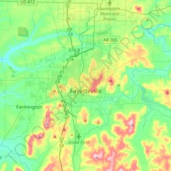
Nombre: Mapa topográfico Fayetteville, altitud, relieve.
Lugar: Fayetteville, Washington County, Arkansas, United States (35.98936 -94.29778 36.14893 -94.02671)
Altitud media: 401 m
Altitud mínima: 325 m
Altitud máxima: 581 m
Fayetteville has a humid subtropical climate (Köppen Cfa). Fayetteville experiences all four seasons and does receive cold air masses from the north; however, some of the Arctic masses are blocked by the higher elevations of the Ozarks.
Otros mapas topográficos
Haga clic en un mapa para ver su topografía, su altitud y su relieve.
Lincoln
United States > Arkansas > Washington County > Lincoln > Lincoln
Lincoln, Washington County, Arkansas, 72744, United States
Altitud media: 439 m