
Haz una donación
Mapa topográfico François Lake
Haga clic en el mapa para ver la altitud.
Haz una donación
François Lake
Equity Silver is a weather station roughly 20 km (12.4 miles) north of François Lake, at an elevation of 1280 m (4199 ft). Equity Silver has a subarctic climate (Köppen Dfc), bordering on a tundra climate (Köppen ET).
Haz una donación
Acerca de este mapa
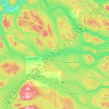
Nombre: Mapa topográfico François Lake, altitud, relieve.
Altitud media: 984 m
Altitud mínima: 564 m
Altitud máxima: 2.251 m
Haz una donación
Otros mapas topográficos
Haga clic en un mapa para ver su topografía, su altitud y su relieve.
Grassy Plains
Canada > British Columbia > Regional District of Bulkley-Nechako > Area E (Ootsa Lake/François Lake)
Altitud media: 911 m
Smaby Peak
Canada > British Columbia > Regional District of Bulkley-Nechako > Area E (Ootsa Lake/François Lake)
Altitud media: 1.740 m
Smoke Mountain
Canada > British Columbia > Regional District of Bulkley-Nechako > Area E (Ootsa Lake/François Lake)
Altitud media: 1.475 m