
Haz una donación
Mapa topográfico Buchenau
Haga clic en el mapa para ver la altitud.
Haz una donación
Acerca de este mapa
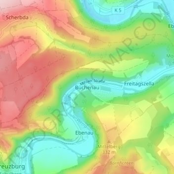
Nombre: Mapa topográfico Buchenau, altitud, relieve.
Altitud media: 284 m
Altitud mínima: 177 m
Altitud máxima: 422 m
Haz una donación
Otros mapas topográficos
Haga clic en un mapa para ver su topografía, su altitud y su relieve.
Eisenach
Germany > Thuringia > Wartburgkreis
Eisenach is situated at the northern edge of the Thuringian Forest, at an elevation of about 220 m. The terrain is hilly, to the south also mountainous (up to 460 m of elevation), with the central Hörsel valley crossing the town in east-western direction. The Nesse river enters the Hörsel river in Eisenach…
Altitud media: 298 m
Eisenach
Germany > Thuringia > Wartburgkreis
Eisenach is at the northern edge of the Thuringian Forest, at an elevation of about 220 m. The terrain is hilly, and to the south also mountainous (up to 460 m of elevation), with the central Hörsel valley crossing the town in east–west direction. The Nesse river enters the Hörsel river in Eisenach after…
Altitud media: 298 m
Haz una donación
Haz una donación