
Gracias por apoyar a este sitio ❤️
Haz una donación
Haz una donación
Mapa topográfico Prunedale
Haga clic en el mapa para ver la altitud.
Gracias por apoyar a este sitio ❤️
Haz una donación
Haz una donación
Prunedale
Prunedale is a census-designated place in Monterey County, California. Prunedale is located 8 miles (13 km) north of Salinas, at an elevation of 92 feet (28 m). The population was 17,560 residents at the time of the 2010 census, up from 16,432 at the 2000 census. Plum trees were grown in Prunedale in the early days of its founding but the trees died soon after due to poor irrigation and fertilizer.
Gracias por apoyar a este sitio ❤️
Haz una donación
Haz una donación
Acerca de este mapa
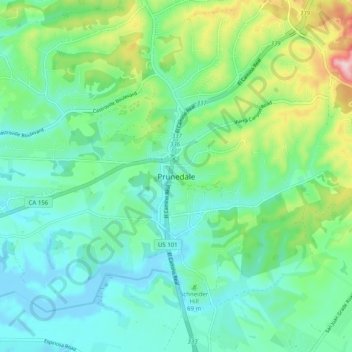
Nombre: Mapa topográfico Prunedale, altitud, relieve.
Altitud media: 69 m
Altitud mínima: -8 m
Altitud máxima: 275 m
Gracias por apoyar a este sitio ❤️
Haz una donación
Haz una donación